Central London Strategy Guide: District Planning, Transit Interchanges & Civic Quarters
Navigating central London efficiently requires coordinating distinct municipal jurisdictions, high-capacity Zone 1 transit corridors, and statutory pedestrian rights of way. Governed within the statutory framework of the Greater London Authority Act 1999 and Transport for London regulatory standards, this strategy blueprint establishes direct operational transit across the Square Mile, West End, South Bank, and South Kensington, cutting transit congestion and clarifying local council bylaws.
🧭 Core District Navigation Strategies
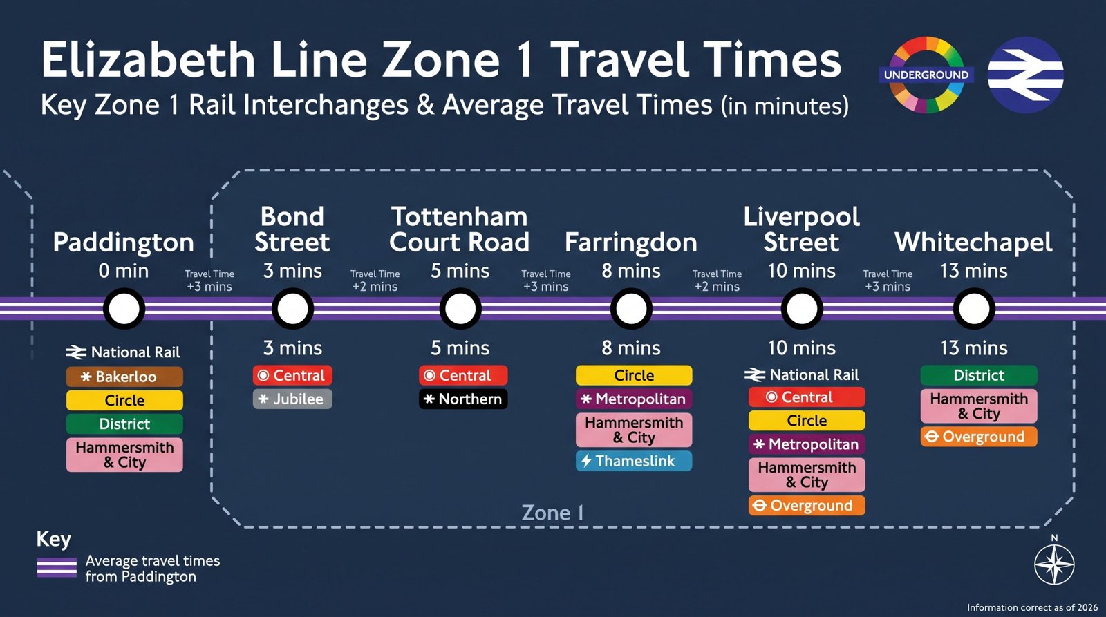
East-West Elizabeth Line Axis
The operational backbone linking Paddington, Bond Street, Tottenham Court Road, Farringdon, and Liverpool Street. Allows 10-minute transit across the West End and City of London, bypassing congested sub-surface lines.
North-South Thames Footbridges
Strategic crossing points including the Millennium Bridge, Hungerford Footbridges, and Waterloo Bridge. Protected public rights of way under the Highways Act 1980 linking Covent Garden and the City to the South Bank arts strip.
Statutory Planning Jurisdictions
Navigating between the sui generis City of London Corporation, Westminster City Council, and the Royal Borough of Kensington and Chelsea. Each enforces distinct licensing hours, conservation bylaws, and waste curfews.
📊 Strategic Comparison: Central District Transit & Operational Profiles
Direct operational comparison outlining strategic transit interchanges, peak congestion dynamics, and statutory governance across central London’s key sectors.
| District | Primary Transit Spines | Peak Operational Window | Planning & Licensing Lead |
|---|---|---|---|
| Square Mile (EC2/EC3) | Elizabeth, Central, Northern, Bank DLR | 07:30–18:30 (Mon–Fri corporate cycle) | City of London Corporation |
| West End (W1/WC2) | Elizabeth, Piccadilly, Central, Northern | 11:00–23:30 (7-day retail & theatre) | Westminster City Council / Camden |
| South Bank (SE1) | Waterloo, Jubilee, Northern, Thames Clippers | 12:00–22:00 (Riverside cultural footfall) | Lambeth & Southwark Councils |
| South Kensington (SW7) | Piccadilly, District & Circle Lines | 09:30–17:30 (Museum visitor flow) | Royal Borough of Kensington & Chelsea |
⏱️ Intermodal Transfer Logistics & Regulatory Codes
Intermodal Rail & River Bus Transfers
Integrating National Rail terminals (Waterloo, Liverpool Street, Paddington, and Charing Cross) with Transport for London (TfL) river bus services creates rapid relief corridors during peak Tube disruption. The River Bus Express links Blackfriars Pier to Westminster Pier in under 12 minutes.
Statutory Public Access & Environmental Byelaws
Central thoroughfares adhere strictly to the Highways Act 1980 public access provisions. Commercial activities, open-air trading, and event filming require licensing via the relevant borough authority in alignment with Greater London Authority environmental and noise abatement protocols.
 Official Verification Hub • Global HQ Digital Stewardship
✉️ Administrative Record Gateway
Direct all statutory submissions, district research inquiries, and network correspondence to our Devon central desk team: Global HQ Central Contact Desk →